DVIDS – News – Response to fishing vessel fire in American Samoa continues, investigation underway
PAGO PAGO, American Samoa — The Coast Guard in American Samoa is continuing to investigate the loss of the commercial fishing vessel Jeanette Friday.
“The vessel poses minimal risk to residents and the environment,” said Lt. Al Blaisdell, supervisor, Marine Safety Detachment American Samoa. “Due to the depth of water, we understand there will be no salvage attempted. Any fuel remaining aboard if released will dissipate quickly. We are continuing with our investigation into the cause of the fire and the sinking.”
Personnel from the MSD began interviews with the crew Thursday. Additional members from Coast Guard Sector Honolulu arrived Thursday to assist. The team will also interview the firefighters, tugboat crew and others to determine the cause of the fire, sinking, and timeline of events.
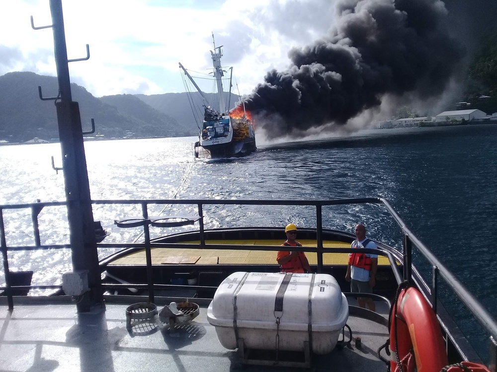
The 228-foot tuna purse seiner caught fire at the commercial cargo pier in Pago Pago Wednesday. Smoke and fire were visible in the main cabin, and local firefighters battled the blaze which consumed nets, interior materials, and even the vessel’s embarked helicopter.
“As the fire continued to burn for several hours concerns were raised over the degrading structural integrity of the vessel under the intense heat, and the weight of the water applied to the fire coupled with the possible impact of the smoke on those nearby and the potential effects of the ship sinking at the pier. The joint decision, spearheaded by the Port Authority, was made to tow the vessel offshore and the port provided a tug to do so. The tug remained with the Jeanette offshore,” said Blaisdell.
The vessel was under tow by a Port Authority tug and still on fire when it began to list and sank Thursday at 10:39 a.m. about 17 nautical miles (19.5 statute miles) southwest of the main island in approximately 3,700 meters (12,140 feet) of water. The tug crew remained on scene to look for pollution and debris. Some small items from the deck drifted free. A small amount of fuel, likely on deck, surfaced and immediately dissipated.
The vessel has a potential fuel load of 90,000 gallons of diesel, 300 gallons of gasoline, as much as 12,000 pounds of ammonia and 1,333 metric tons of fish aboard. As the ship recently returned from fishing, it is unlikely the full fuel load was aboard. There are 22 crew members associated with the boat, but no one was aboard at the time of the fire, and no injuries reported.
Following consultation with NOAA’s scientific support team, shoreline impacts based on the available data are unlikely. Any diesel released may form a sheen that will dissipate and be moved to the west by currents and winds. In high winds, a sheen may not be visible at all. Responders are conducting shoreline assessments along the southern coast of Tutuila Island and a possible overflight of the location of the sinking by civilian helicopter.
“It’s unknown how much if any fuel remains aboard the Jeanette,” said Blaisdell. “If there is any sheening we anticipate it is unrecoverable and will break up quickly and evaporate. The vessel is not a threat to navigation or fishing grounds. Our focus now is understanding how this happened and work to prevent future occurrences. This incident is a major marine casualty, and we are conducting our investigation jointly with the National Transportation Safety Board.”
Through the investigation process, the Coast Guard and NTSB will gather information about the accident including interviews, vessel history, event timeline and much more to determine the cause of the fire and sinking. The Coast Guard’s primary goal is to prevent future incidents and protect the safety of mariners and the ports. The full investigation, to include the collection of data, analysis, summary report and approval of that report by Coast Guard Headquarters is expected to take several months at a minimum. The results will be available once reviewed and approved.
The story was published at Fishery Nation Dec. 8, 2018. It may be found at http://fisherynation.com/archives/76722. It may also be found at Fisher Forum, a fisheries site out of Denmark related to the diverse crews operating in American Samoa, published Dec. 10, 2018, found at http://www.fiskerforum.dk/en/news/b/investigation-launched-into-seiner-fire-and-loss. It was also published in NOAA’s Incident News.
| Date Taken: | 12.07.2018 |
| Date Posted: | 12.07.2018 18:39 |
| Story ID: | 302688 |
| Location: | AS |
| Web Views: | 956 |
| Downloads: | 1 |

 Private Internet Access gives you unparalleled access to thousands
of next-gen servers in over 83 countries and each US state. Your
VPN experience will always be fast, smooth, and reliable.
