DVIDS – News – NRL meteorologist tracks transcontinental dust storms’ magnitude and impact
By K. Cecilia Sequeira, U.S. Naval Research Laboratory Corporate Communications
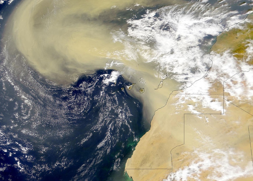
WASHINGTON — The amount of dust flying out of the Sahara Desert each year is seemingly unfathomable. Every year, 14 million metric tons of transcontinental dust travels across the Atlantic Ocean, said Arunas Kuciauskas, a U.S. Naval Research Laboratory meteorologist who tracks and quantifies the Saharan Air Layer (SAL).
These dust storms envelop whole communities — blanketing homes, cars and people.
NASA research scientists estimate it would take 53,022 semi-trucks to move enough desert sand to equal the amount of dust transported from Northern Africa to the Greater Caribbean annually.
How do these dust clouds affect community health? Can forecasters predict the large dust storms to help prepare affected communities? Healthcare professionals and meteorologists across the globe consider these questions every spring and summer when the northeasterly trade winds begin to pick up Saharan dust and scatter it across thousands of miles.
This meteorological phenomenon involves an extremely hot, dry air mass, carrying large concentrations of Saharan dust from Northern Africa across the Atlantic Ocean into the Greater Caribbean, South America, the Gulf of Mexico and southeastern United States.
Kuciauskas collaborates with researchers at NASA, National Oceanic and Atmospheric Administration (NOAA), and Caribbean organizations to model the Saharan dust storms and provide prediction tools to weather forecasters and healthcare professionals in the affected regions. One of the new forecasting resources he uses to track and quantify SAL events is the NOAA Unique Combined Atmospheric Processing System or NUCAPS, a software tool that processes radiance data from satellite measurements collected by NOAA’s Joint Polar-orbiting Satellite System (JPSS) into thermodynamic parameters that describe the SAL.
Kuciauskas, the principal investigator for Caribbean dust research at NRL’s Marine Meteorology Division, Monterey, California, has teamed with NOAA Science and Operations Officer Ernesto Rodriguez using NUCAPS to track and measure the size and power of regional dust storms. Rodriguez works at the National Weather Service in San Juan, Puerto Rico. Their research will lead to regional weather forecast alerts indicating each system’s severity days before the dust arrives.
Kuciauskas and Rodriguez will establish a baseline expectation for SAL events in the region using a 17-year climatology over the Caribbean and statistical averaging. The San Juan National Weather Service aims to develop a traffic light prediction approach where a “green” Saharan dust event indicates low impact, a “yellow” event is average and a dust storm classified as “red” is dangerous to the affected population.
Once developed, the National Weather Service in San Juan can use the traffic light approach to alert the public to upcoming SAL-related hazardous air quality conditions four to five days in advance. Equipped with sufficient time and information, at-risk populations with respiratory ailments facing a “red” air quality event may choose to stay inside. Residents in affected populations may cover machinery with tarps to avoid clogging mechanical parts. Local flights may adjust course or schedules.
Small aircraft traveling between Caribbean islands are the most affected by SAL events.
“They usually fly at low altitudes, around 3-5 kilometers, where the Saharan dust is transported,” Rodriguez said. “An accurate forecast of a SAL event will provide enough lead time to the aviation and maritime community to plan the operations, taking into account the visibility reduction and the poor air quality.”
The U.S. Navy also benefits from early SAL forecasts. Navy meteorologists monitor weather conditions over huge swaths of ocean and collect data from rawinsondes, which consist of airborne weather instruments used to measure temperature, moisture, and wind profiles from the surface to the top of the earth’s atmosphere. This information is applied to study various weather-related properties of SAL.
Numerous global land-based sites routinely launch rawinsondes. Over the oceans or other bodies of water, rawinsondes are too sparsely located to provide a reasonable picture of SAL events, said Kuciauskas. By contrast, NUCAPS gathers information from satellites that provide continuous measurements over oceans allowing forecasters to see clearly vertical profiles containing similar information to what is available over land.
“In the case of SAL, we are able to create a really good picture on a daily basis on the dryness, temperature and lapse rate,” Kuciauskas said. Using NUCAPS, meteorologists can determine if an incoming SAL event will “come in and stabilize everything versus what it is now,” he said.
Saharan dust storms often overlap with the summer hurricane season creating a curious effect on each other. Saharan dust storms consist of dry, hot air and particulates, while hurricane development relies on wet and relatively cool conditions within its path. When these two systems meet, they cancel each other out or one reduces the impact of the other.
The NUCAPS software allows forecasters to look ahead at air quality and affect SAL events may have on incoming hurricanes. Kuciauskas said Navy forecasters are interested in tracking these storms in the same way as other meteorologists. “If you have that information available, the Navy can plan their daily maneuvers across the Atlantic basin,” said Kuciauskas.
NUCAPS is a publically available tool. Kuciauskas has trained civilian U.S. and international forecasters throughout the Caribbean on how to use the program to profile Saharan dust storms. The new tool is becoming increasingly popular in the region because it distinguishes between different aerosols affecting the Caribbean. NUCAPS provides data on the carbon monoxide and ozone gases and differentiates between a Saharan dust storm and smoke pollution from a fire traveling across the Atlantic.
Kuciauskas plans to introduce and train meteorologists at NRL – Monterey and the Fleet Numerical Meteorology and Oceanography Center to leverage NUCAPS for similar regional predictions with designs to become an invaluable addition to global Navy operations.
The team at NRL – Monterey shares thousands of satellite-derived products via NRL’s public websites every day. Early impact warnings associated with Saharan dust storms may eventually enable state and federal agencies to greatly minimize SAL impacts on public health in the Caribbean.
The NUCAPS forecasting tool is part of the Advanced Weather Interactive Processing System, which every national weather service in the U.S. can access. U.S. Navy meteorologists can also access NUCAPS via the NOAA website.
About the U.S. Naval Research Laboratory
NRL is a scientific and engineering command dedicated to research that drives innovative advances for the Navy and Marine Corps from the seafloor to space and in the information domain. NRL headquarters is located in Washington, D.C., with major field sites in Stennis Space Center, Mississippi; Key West, Florida; and Monterey, California, and employs approximately 2,500 civilian scientists, engineers and support personnel.
| Date Taken: | 02.25.2020 |
| Date Posted: | 02.25.2020 06:17 |
| Story ID: | 363804 |
| Location: | US |
| Web Views: | 121 |
| Downloads: | 1 |
PUBLIC DOMAIN
This work, NRL meteorologist tracks transcontinental dust storms’ magnitude and impact, must comply with the restrictions shown on https://www.dvidshub.net/about/copyright.


 Private Internet Access gives you unparalleled access to thousands
of next-gen servers in over 83 countries and each US state. Your
VPN experience will always be fast, smooth, and reliable.
